GEOREFERENCING
Converting a raster data-set from
image space to a real-world coordinate system is called Geo-referencing.
1 How to Map
Kml image in a location where we selected from the Google earth in to the
ArcMap Layer?
Steps,
- Select a place you like from the Google Earth, and add a placemark where you need.
2. Then add another four
placemark around your previous placemark (Practice 1), (make sure that you can
identify the placemark clearly in the future step)
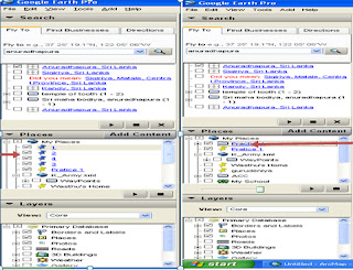
3. Then left side of the google earth you can see
“Places ”windo. In that window you have your placemark (1,2,3,4). Now u have to
create a folder there and drag and drop those placemarks in to your folder.
(Just right cliking on the places window you can create a
new folder)
4.
Then right click on your folder and save as kml
file.
5.
Then save the location you have selected in the
Google Earth, if you are use Google Earth Pro you can select following
resolutions,
6. Now we have created Kml file, then we need get that Kml file in to ArcGIS for that open ArcMap.
7. First of all we have to change the “Projection” of the layer in to “Kandawala” (If you select a country except Sri Lanka then you have to select coordinating system according to selected country, otherwise you can select “WGS 1984”)
8.
In ArcMap select the “Windows” tool and from the
drop down list select “Search ” option or Ctrl+F. then type “Kml to Layer”, then
press Enter.
10.
Then ArcMap will add Kml file in to layer, if you have done it
properly Arcmap will display a massage
and also you can see your Placemarks in the ArcMap, (you can select either KML or KMZ)
11. Now you have to change the projection of the
added KML or KMZ file by using tool “Project”, because our KML file is in WGS
1984 coordinating system.
12.
Then do following steps to add your placemarks
in to the ArcMap,
- Go to “Input dataset of Feature class” and select for search and select the file (It is in .gdb format)
- Then select the “placemarks”
- Then as we did earlier we have to change the coordinate system in to “Kandawala”,
13. Now you can see two layer one is your previous placemarks which is on “WGS 1984” coordination system and your new placemarks which is in “Kandawala ” coordinating system. (You have to select the coordinating system according to the country that you captured the placemarks)
14. Now we have to add the Google image we saved in to ArcMap, therefore right click on the “Layers ” and select “Add data” of select the “+” in the tool bar, then select the saved Google Earth “jpg” image.
15. Then you can see jpg image been taken in to layers, (if you can not see your image or placemarks, always right click on the particular layer and select “Zoom to Layer” )
(Once we have placemark which is
in we assigned coordinate system , we have to remove or un-tick the other
placemarks )
16. Now we have to map the image with placemarks, for that we can use “add control points” tool, (You can get this tool from Georeferencing tool bar, Go to customize /Toolbars/ Georeferencing)
17. From our image placemark 1 have to map with placemark 1 in the ArcMap, same as for other placemarks have to map.
19. Finally you have to update the Georeferencing, for that go to Georeferencing toolbar, go to Georeferencing and “Update Georeferencing”.


No comments:
Post a Comment